

")
Current Snapshot
For all the latest updates visit: DisasterAWARE
1800x1080a
melissa
close
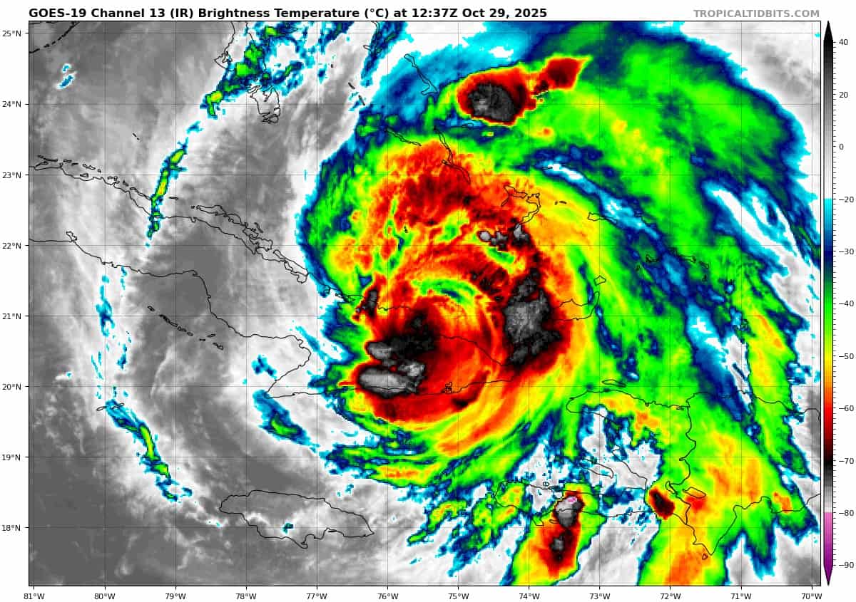
goes19_ir_13L_202510291237_lat20.7-lon-75.8
291149_earliest_reasonable_toa_34
291149INTQPF_sm
13L_tracks_latest
By PDC’s Senior Weather
Specialist Glenn James

The Pacific Disaster Center’s (PDC Global) Wednesday, October 29, 2025, Tropical Cyclone Activity Report…for the Atlantic Ocean, the Caribbean Sea, and the Gulf of America
Current Tropical Cyclones:
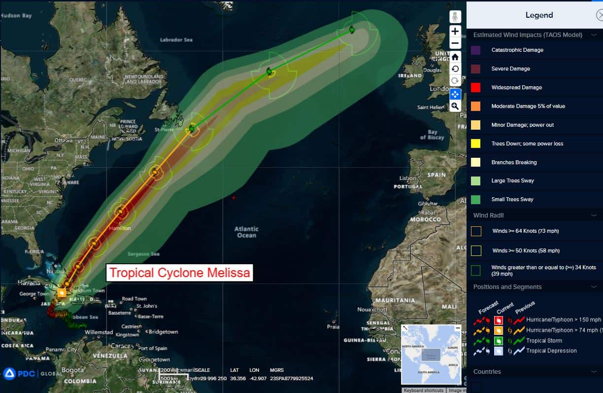
Tropical Cyclone Melissa…is located about 860 miles southwest of Bermuda
Atlantic Ocean:
Tropical Cyclone Melissa
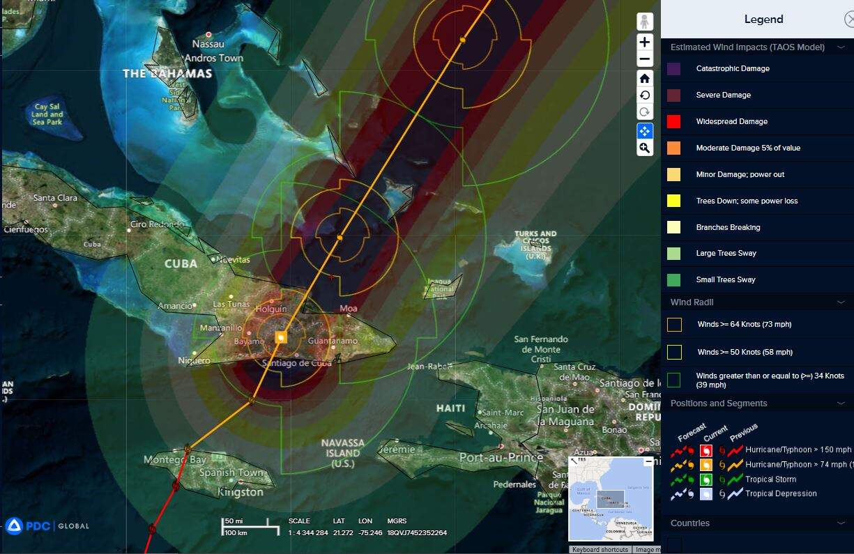
MELISSA PRODUCING DAMAGING WINDS, FLOODING RAINS, AND A DANGEROUS STORM SURGE IN THE BAHAMAS
According to the NHC advisory number 34A
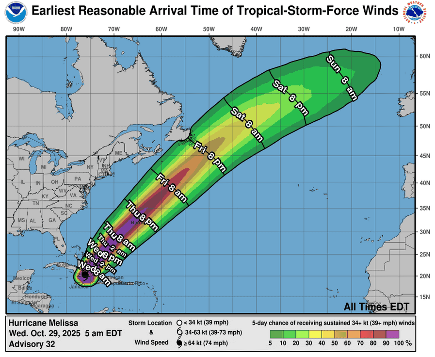
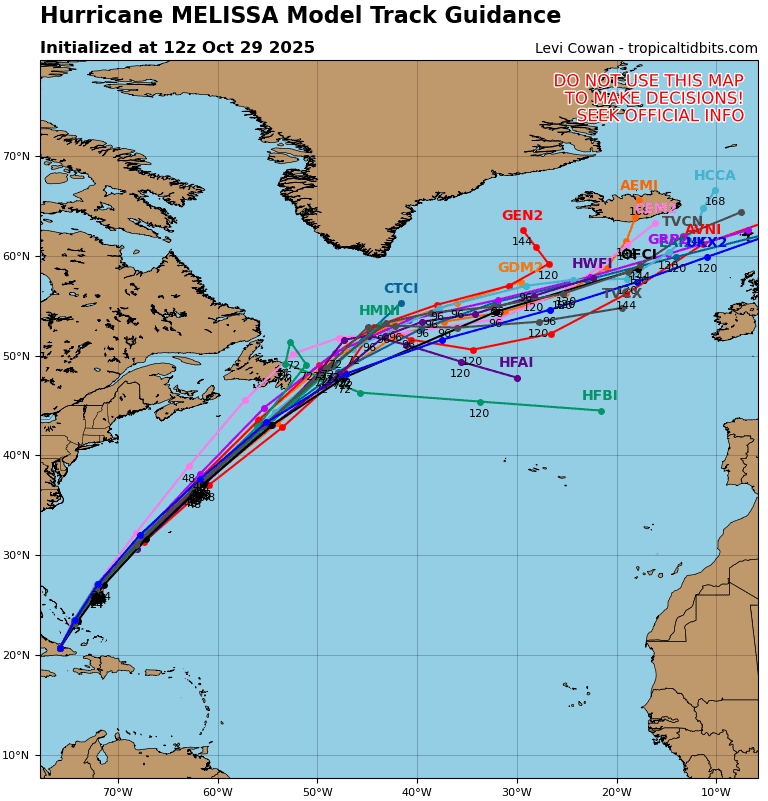
Melissa is moving toward the north-northeast near 16 mph (26 km/h). An accelerating northeastward motion is expected during the next few days. On the forecast track, the core of Melissa is expected to continue to move across the southeastern or central Bahamas this evening, and is forecast to pass near or to the west of Bermuda late Thursday and Thursday night.
Maximum sustained winds are near 90 mph (150 km/h) with higher gusts. Some restrengthening is forecast tonight into tomorrow with weakening beginning thereafter.
Hurricane-force winds extend outward up to 60 miles (95 km) from the center and tropical-storm-force winds extend outward up to 185 miles (295 km). A private weather station at Pitts Town on Crooked Island recently reported sustained winds of 76 mph (122 km/h) and a wind gust of 85 mph (137 km/h). The estimated minimum central pressure is 970 mb (28.65 inches) based on dropsonde data.
HAZARDS AFFECTING LAND
WIND: Hurricane conditions are occurring within the warning area in the southeastern and central Bahamas and should continue through tonight. Tropical storm conditions are ongoing in the Turks and Caicos Islands and should continue through tonight.
Hurricane conditions are now expected on Bermuda late Thursday and Thursday night with Tropical storm conditions expected earlier on Thursday.
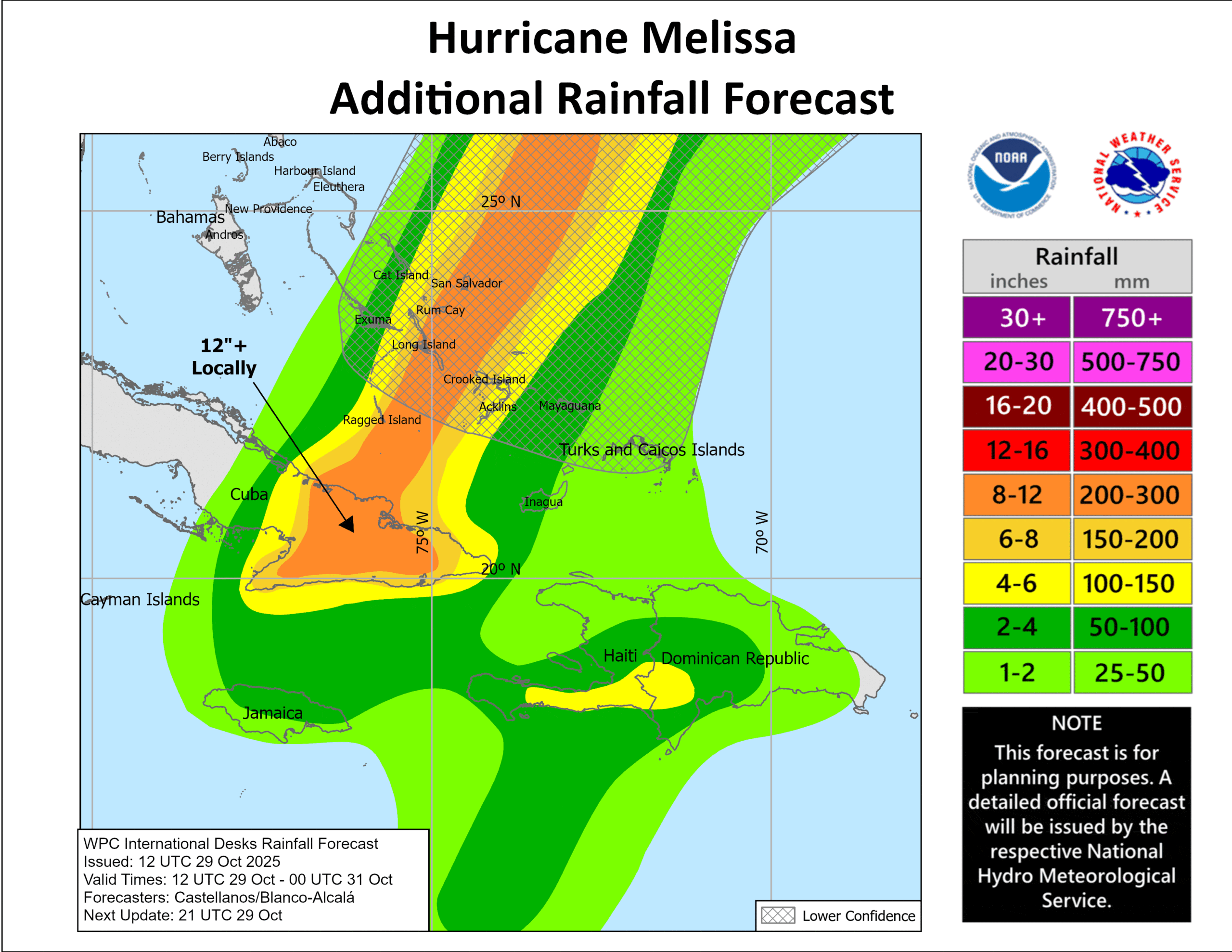
RAINFALL: Over the Southeast Bahamas, storm total rainfall of 5 to 10 inches are expected through Thursday morning, which will result in areas of flash flooding. For the Turks and Caicos rainfall totals of 1 to 3 inches are expected. Heavy rain may begin to affect Bermuda on Thursday or Thursday night.
Over southern Hispaniola, additional rainfall of 1 to 2 inches are through this evening, with storm total local maxima of 40 inches possible.
For eastern Cuba, the rainfall has subsided. However, additional scattered showers are expected through this evening, with additional rainfall amounts of 1 to 2 inches. With storm total rainfall of 10 to 20 inches, possibly up to 25 inches over mountainous terrain, the ongoing life-threatening and potentially catastrophic flash flooding and landslides will likely persist into the evening.
SURF: Swells generated by Melissa will continue to affect portions of Hispaniola, Jamaica, eastern Cuba, the Cayman Islands for the remainder of the day, will affect the Bahamas and the Turks and Caicos Islands for the next few days, and will spread toward Bermuda later this week, causing life-threatening surf and rip current conditions.
STORM SURGE: Storm surge of 4 to 7 ft above normally dry ground is possible in the southeastern Bahamas tonight, and minor coastal flooding is possible in the Turks and Caicos Islands tonight.
Caribbean Sea: There are no active tropical cyclones
Tropical cyclone formation is not expected during the next 7-days.
Gulf of America: There are no active tropical cyclones
Tropical cyclone formation is not expected during the next 7-days.